
")
Storm Alert – September 29, 2024 – Post Tropical Cyclone Helene
In the aftermath of Helene, fuel markets are still recovering. While many fuel markets have partially or fully reopened, not all markets have seen improvement. North Augusta, a market spanning the coastal South Carolina and Georgia border, continues to face power outages, leading to long-hauls from surrounding markets to meet local demand. In other areas, partially open terminals and heavy post-storm demands are creating constraints that slow deliveries. Drivers have reported 4-5 hour lines to fill fuel trucks at some terminals.
Even after supply markets are fully re-opened, logistics delays could present problems for days or weeks. Helene caused historic flooding in many areas, washing away bridges and roads. As of yesterday, North Carolina reported roughly 400 roads closed, including all but one of the major highways leading into Asheville. Tennessee also had several road closures and a reported bridge collapse. Re-opening these roads will take time, forcing fuel carriers in affected regions to drive longer routes.
Florida, excluding Pt Ev and Jacksonville, remains on Code Red as markets work to catch up on deliveries. Mansfield is also adding North Augusta and surrounding markets to Code Red, given the continued terminal outage making long-hauls a necessity. For Code Red markets, Mansfield requests that customers provide 72-hr notice for new deliveries. Georgia, Alabama, and the rest of South Carolina remain on Code Orange, with a 48-hour lead time requested.
With the heavy rains and flooding, ensure your fuel tanks are free of water to prevent any damage or operational issues. For more information on post-storm recommendations, check out our What to Do After the Storm FUELSNews guide.
More Storms in the Forecast
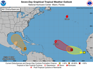
Mansfield is also monitoring several other potential storms that could impact the US. One tropical disturbance in the Caribbean Sea has a 50% chance of forming in the next 7 days, following a path similar to Helene. In the Atlantic, several storms have either formed or could potentially form, though none are close enough to predict whether or where a landfall may occur. Tropical Storm Joyce is expected to turn north and dissipate over the coming week.
This article is part of Alerts
Tagged:
MARKET CONDITION REPORT - DISCLAIMER
The information contained herein is derived from sources believed to be reliable; however, this information is not guaranteed as to its accuracy or completeness. Furthermore, no responsibility is assumed for use of this material and no express or implied warranties or guarantees are made. This material and any view or comment expressed herein are provided for informational purposes only and should not be construed in any way as an inducement or recommendation to buy or sell products, commodity futures or options contracts.

 (1)")
")
