NOAA Predicts Above-Normal Atlantic Hurricane Season Due to Warmer Ocean Temperatures
The National Oceanic and Atmospheric Administration (NOAA) announced that the Atlantic hurricane season is expected to be more active than usual this year. The agency attributes this prediction to near-record high ocean temperatures and the development of La Niña conditions. The Atlantic hurricane season officially runs from June 1 to November 30.
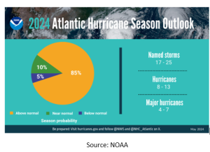
According to the NOAA’s National Weather Service forecasters, the 2024 hurricane season will likely see between 17 to 25 named storms. Of these, 8 to 13 are anticipated to reach hurricane strength, and 4 to 7 could develop into major hurricanes characterized by winds of 111 mph or higher.
This forecast follows a relatively quiet 2023 hurricane season, which recorded 19 named storms, seven hurricanes, and three major hurricanes, with four storms impacting the United States.
NOAA has assessed the probability of an above-normal hurricane season at 85%. There is a 10% chance of experiencing an average season and a 5% chance of below-average tropical activity.

NOAA’s forecast aligns with an earlier prediction made by Colorado State University in April, which called for a record 23 named storms this year, 11 of which are expected to reach hurricane strength. This is notably higher than the average of 14.4 named storms and 7.2 hurricanes recorded between 1991 and 2020.

The agency’s outlook is based on several factors, including reduced trade winds and wind shear, which typically inhibit tropical storm formation, near-record warm Atlantic Ocean temperatures, and La Niña conditions. La Niña is characterized by cooler surface water temperatures in the equatorial Pacific Ocean, which tend to favor tropical storm formation.
NOAA also forecasts a potential shift to La Niña conditions from one of the strongest El Niños observed earlier this year. Additionally, an above-normal West African monsoon season is expected, which can generate African easterly waves that often develop into some of the strongest and longest-lasting Atlantic storms.
The combination of light trade winds and reduced wind shear allows hurricanes to intensify without disruption and minimizes ocean cooling. NOAA emphasizes that human-caused climate change is exacerbating these conditions. Melting ice and warming oceans are contributing to rising sea levels, thereby increasing the risk of hurricane-related storm surges.
The agency plans to update its hurricane outlook in early August, just before the season’s peak.
Preparing for the Unpredictable
Natural disasters have historically wreaked havoc on the energy sector, resulting in significant economic losses. While the energy market takes a hit when storms strike the U.S., implementing well-informed strategies based on past disasters, understanding hurricane dynamics, and grasping fuel behavior can significantly reduce risks and facilitate swift recovery.
Mansfield Energy, North America’s leading fuel distributor, brings a wealth of expertise to the table in creating a robust emergency response program tailored to your company’s needs. Mansfield’s program offers a multi-tiered approach, prioritizing essential services and collaborating closely with partners to ensure seamless fuel distribution during emergencies. Contact us today!

This article is part of Daily Market News & Insights
Tagged: Hurricane season, NOAA, predictions
MARKET CONDITION REPORT - DISCLAIMER
The information contained herein is derived from sources believed to be reliable; however, this information is not guaranteed as to its accuracy or completeness. Furthermore, no responsibility is assumed for use of this material and no express or implied warranties or guarantees are made. This material and any view or comment expressed herein are provided for informational purposes only and should not be construed in any way as an inducement or recommendation to buy or sell products, commodity futures or options contracts.


