Storm Alert – September 23, 2024 – INVEST 97L
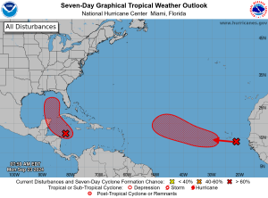
Just when the Gulf of Mexico thought it was in the clear, another tropical disturbance is on the rise and projected to impact the area later this week. Currently, in the Caribbean Sea, the area of low pressure known as Invest 97L is organizing quickly and has the characteristics of becoming a tropical storm or hurricane within the next few days as it moves north toward the Gulf of Mexico. “Helene” is the next storm name on the 2024 Atlantic hurricane list and the National Hurricane Center has given the system a 90% chance of formation over the rest of the week. No matter the development of the storm, heavy rainfall is expected over Central America.
Although it’s still uncertain if Invest 97L will directly impact Florida, models suggest it could turn northeast in the Gulf of Mexico. Florida is expected to experience tropical rainfall mid-week through the weekend.
A tropical wave in the eastern Atlantic has a 50% chance of development, with the possibility of forming into a tropical depression next week.
Mansfield has been proactively tracking these storms and working to replenish inventory at all managed locations in preparation for the week ahead. Mansfield will continue monitoring these storms and will provide updates as more information becomes available.

This article is part of Alerts
Tagged:
MARKET CONDITION REPORT - DISCLAIMER
The information contained herein is derived from sources believed to be reliable; however, this information is not guaranteed as to its accuracy or completeness. Furthermore, no responsibility is assumed for use of this material and no express or implied warranties or guarantees are made. This material and any view or comment expressed herein are provided for informational purposes only and should not be construed in any way as an inducement or recommendation to buy or sell products, commodity futures or options contracts.


