Calm Before the Storm? Hurricane Season Isn’t Over Yet
Early September is typically when hurricane season peaks, with the Atlantic expected to be active. However, this year, the ocean has been unusually calm. Since Hurricane Ernesto in mid-August, no storms have formed, marking the longest lull in activity in 56 years. Despite this calm, experts caution that the season’s peak is still ahead, with over 40% of tropical storm activity historically occurring after September 10.
According to the National Hurricane Center’s (NHC) forecast, a broad area of low pressure in the southwestern Gulf of Mexico is likely to develop into a significant weather system early this week. If named, the storm will be called Francine, ending the period of calm for hurricane-prone areas.
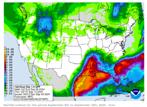
The center expects the system to develop into a tropical storm by Monday and strengthen into a hurricane before making landfall, likely along the northwestern US Gulf Coast on Wednesday. This could bring a heightened risk of life-threatening storm surge and hurricane-force winds to the Louisiana and upper Texas coasts.
2024 Hurricane Season Forecast
Before the season began, predictions indicated that conditions were preparing for an active year, with expectations of over 20 named storms. Early in August, The National Oceanic and Atmospheric Administration (NOAA) reaffirmed its prediction for a “highly active” Atlantic hurricane season in 2024.

As we pass the halfway point of hurricane season, which spans from June 1 to November 30, there have been only five named storms: Alberto, Beryl, Chris, Debby, and Ernest. Three of these became hurricanes, with Beryl reaching major storm status as a Category 5 hurricane. Warm ocean waters, minimal wind shear, and moist air — the ingredients for storm formation — were all in place.
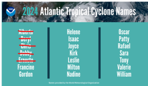
This calm came despite record-high sea surface temperatures across the Atlantic, which initially fueled expectations of an active season. The season started with Hurricane Beryl, an unusually powerful Category 5 storm early in the season, signaling what was thought to be the beginning of a hyperactive period. But since then, the conditions needed for storm formation haven’t aligned.
The strange behavior of the current hurricane season could be a glimpse of what lies ahead as the planet continues to warm. Extreme atmospheric conditions, driven by climate change, are believed to be influencing this calm. Scientists have long warned that global warming would result in fewer but more intense storms, a pattern that may be emerging this season.
One major factor influencing the lack of storm formation is the unusual movement of storm systems off the coast of Africa. Normally, hurricanes form from stormy weather that moves westward from Central Africa. However, this year, these systems have been pushed farther north than usual, some even venturing into the Sahara Desert — a region notorious for its dry, dust-laden air stifling storm development. Cooler waters near the northwest African coast have also contributed to the current drought of storms.
A Look back into the 2023 season
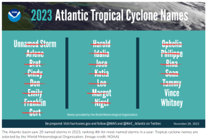
According to NOAA data, the 2023 Atlantic hurricane season ranked 4th for most-named storms in a year, with a total of 20 named storms. Of these, seven developed into hurricanes, and three became major hurricanes. In comparison, an average season typically sees 14 named storms, seven hurricanes, and three major hurricanes.
What’s Next for the 2024 Season?
Looking ahead, areas closer to the Caribbean, the US Gulf Coast, and even the southeastern US can still face storm threats. The waters in these regions remain exceptionally warm, and as the season progresses, this warmth could fuel late-season hurricanes. Additionally, a developing La Niña, expected to strengthen throughout the fall, could lead to an uptick in storm activity in October and November.
Are you prepared? Talk to the experts!
Despite the lull – that might end with Francine -, it’s important to exercise caution. The calm seas do not signal the end of the season, and storms can still emerge with little warning. Those in hurricane-prone areas should remain vigilant and prepared for potential developments.
Mansfield Energy, North America’s leading fuel distributor, brings a wealth of expertise to the table in creating a robust emergency response program tailored to your company’s needs. With an extensive network servicing the US and Canada, Mansfield understands the critical importance of proactive measures in facing potential disruptions caused by hurricanes or other natural disasters.
Leveraging in-depth knowledge, Mansfield has developed a comprehensive Emergency Response Fuel Program that prescribes industry best practices. Mansfield’s program enables a multi-faceted approach, prioritizing essential services and collaborating closely with partners to ensure seamless fuel distribution during emergencies. Contact us today!
This article is part of Daily Market News & Insights
Tagged: Hurricane season, Storm Season
MARKET CONDITION REPORT - DISCLAIMER
The information contained herein is derived from sources believed to be reliable; however, this information is not guaranteed as to its accuracy or completeness. Furthermore, no responsibility is assumed for use of this material and no express or implied warranties or guarantees are made. This material and any view or comment expressed herein are provided for informational purposes only and should not be construed in any way as an inducement or recommendation to buy or sell products, commodity futures or options contracts.


